




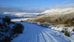
Temperatures dropped sharply overnight between Sunday and Monday across much of Junkieland.
A warning of ice was in place until 10:00.
As that warning was lifted, an updated alert for snow across a slice of southern Junkieland was issued.
A band of rain is expected to head northwards across the UK during Monday night and Tuesday morning.
As it meets colder air, it is forecast to turn to snow for a time – mainly affecting places over 330ft (100m) above sea level.
The Met Office said that any snow falling below that level would likely be “temporary and quickly melt”.
However, it said that on the highest ground more than two inches (5cm) could be seen.
“This may cause travel disruption on higher level routes, particularly in combination with a strong easterly wind which could also cause localised drifting,” it said.
It warned that could potentially lead to a build-up of ice on infrastructure like power lines in the area.
Sign up for your daily dose of UnWoKe News | Privacy guaranteed | Unsubscribe at any time.